I-10 Loop 202 to State Route 387 Wild Horse Pass Corridor

WATCH FOR overnight LANE RESTRICTIONS ON EASTBOUND & westbound I-10
Interstate 10 (I-10) between Phoenix and Tucson is critical for Arizona’s economy, as it links the state’s two largest metropolitan areas while also providing a key link for the national and international movement of freight. Arizonans use this route to commute to and from the cities daily from rural communities. This route also serves the Gila River Indian Community by providing key connections to employment, medical, educational, and other necessary services both within and outside of the Community.
Since about 2005, Arizona Department of Transportation (ADOT) had been expanding the capacity of I-10 between Phoenix and Tucson in segments. By 2019, I-10 consisted of three lanes in each direction between SR 387 near Casa Grande and Tucson. That left the 26 miles of I-10 across the Gila River Indian Community as the only remaining stretch with two lanes in each direction.
In the summer of 2019, ADOT and partner agencies took the essential first step toward studying ways to increase the capacity of a 26‑mile section of I-10 south of the Phoenix metropolitan area.
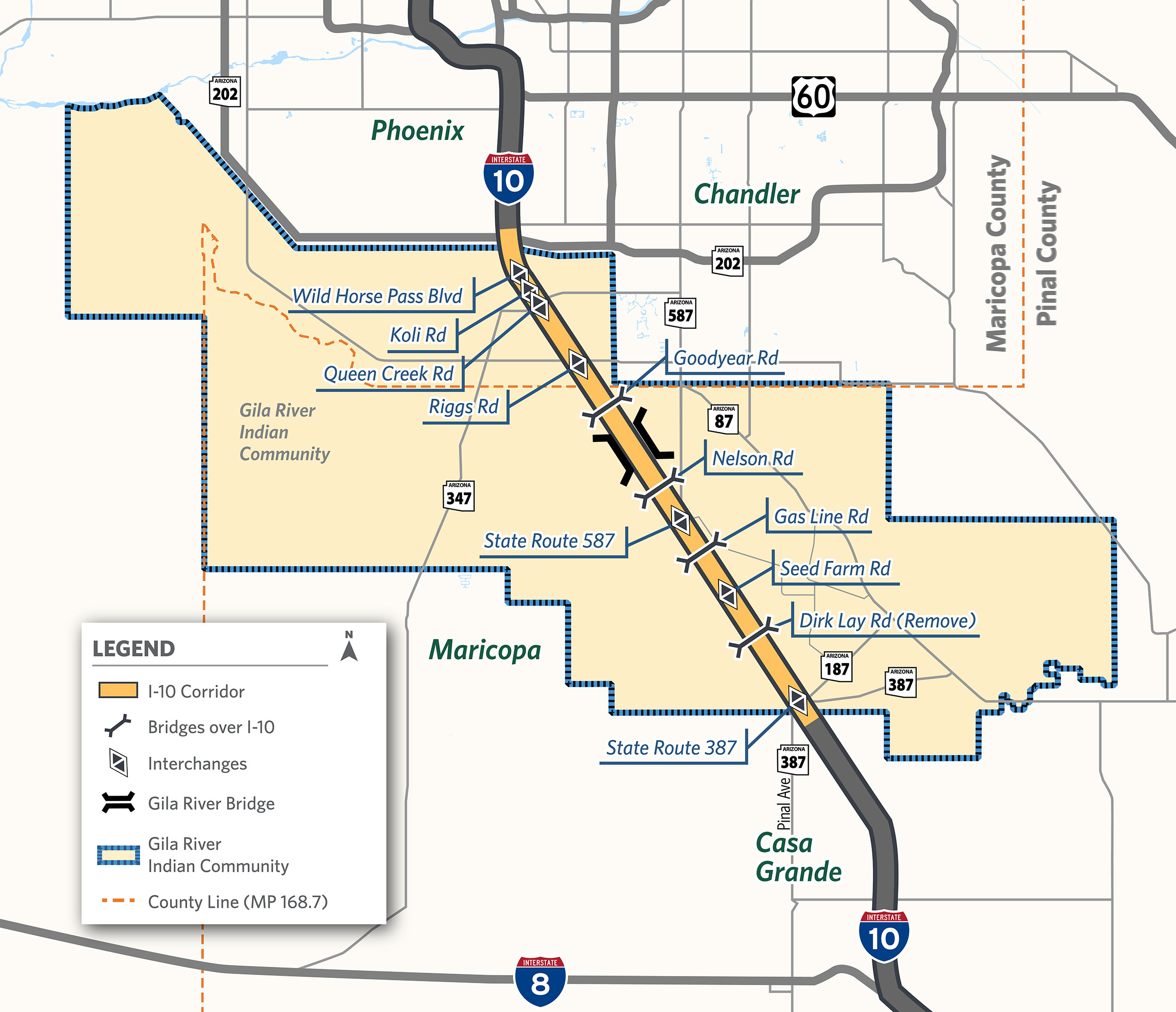
The study focused on the 26-mile section of I-10 between the Loop 202 interchange south of Phoenix to just south of the State Route (SR) 387 interchange near Casa Grande. This section of I-10 was labeled the Wild Horse Pass Corridor. It was the last remaining segment of I-10 between Phoenix and Tucson that had only two lanes in each direction.
The I-10 bridges over the Gila River were part of a separate ADOT project that was excluded from the overall corridor study but closely coordinated with the Community.
In collaboration with the Gila River Indian Community, the Bureau of Indian Affairs (BIA), the Federal Highway Administration (FHWA) and Maricopa Association of Governments (MAG), ADOT prepared an environmental study under the National Environmental Policy Act (NEPA) and an engineering study to evaluate improvements to I-10. This study was important because I-10 supports significant commercial and economic growth for the region, state and nation, and is considered a key commerce corridor.
The study process produced a NEPA-compliant environmental report (an Environmental Assessment [EA]) and an engineering report called a Design Concept Report (DCR) that:
In 2022, the Final Project Assessment for the Gila River Bridge replacement was completed, and then in 2023, the Final Categorical Exclusion environmental document for that project was also completed. These documents can be found below in the Corridor Documentation section.
In early 2024, the Final Environmental Assessment, the Finding of No Significant Impacts (FONSI), and the Final Design Concept Report were completed for the I-10 Wild Horse Pass Corridor study.
ADOT, as the lead agency and project sponsor, in collaboration with the Gila River Indian Community (Community), the BIA, the FHWA and MAG, initiated an EA and Design Memo (DM) for the proposed I-10/Koli Road Traffic Interchange. The public scoping and alternatives process provided the opportunity for the community and public to educate the study team about the I-10/Koli Road Traffic Interchange study area, as well as share concerns about modifying I-10 to incorporate a proposed traffic interchange at approximately Koli Road. This input helped ADOT, the Community, and MAG select a Recommended Build Alternative for this section of I-10 and Koli Road. The I-10/Koli Road Traffic Interchange Study Public Hearings were held on July 29 and July 30, 2025, to provide the public with an opportunity to review the draft EA and DM and submit formal comments about the Recommended Build Alternative. In late 2025, the Final Environmental Assessment, the Finding of No Significant Impacts (FONSI), and the Final Design Memo were completed for the study. These documents, along with other related corridor documents and resources, are posted in the Corridor Documentation section below.
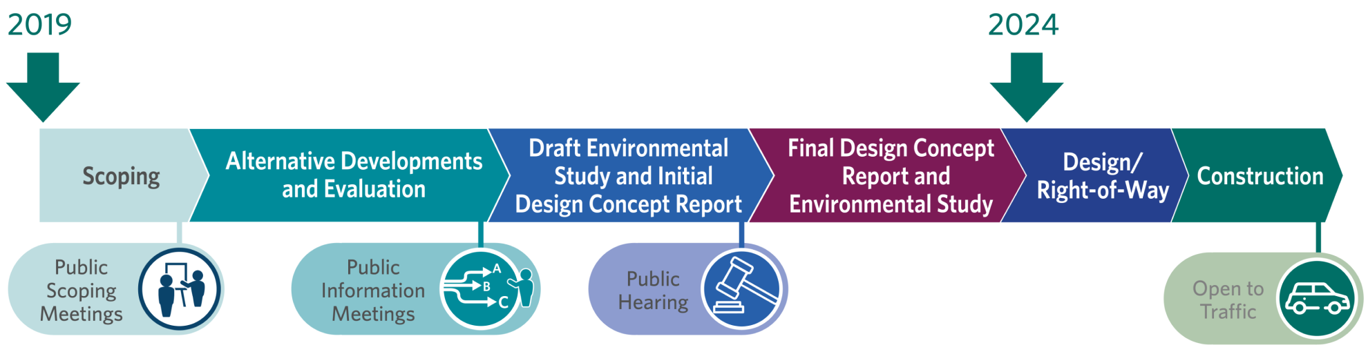
The timeline below depicts the corridor planning process steps that were followed by ADOT and the project stakeholders.
Environmental and engineering documents, visualizations, and public meeting and hearing documents for the I-10 Wild Horse Pass Corridor Study and I-10/Koli Road Traffic Interchange Study are available on request. Please email i10wildhorsepasscorridor@hdrinc.com to request copies of the documents.